HOTEL ORTADOĞU
Mountain Ağrı
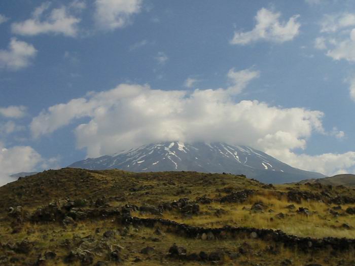
Mount Ağrı, which is not only Turkey's but also Europe's most highest peak with a height of 5137 and mounting on the north - eastern part of Doğubayazıt valley, is one of the volcanic mountains which has the highest potential in connection with mountaineering tourism of our country.
Mount Ağrı has all the characteristics that people who are interested in mountaineering seek for. The mountain has not only easy routes for amateur mountaineers to climb easily, but also it has difficult routes for professionals. Having a high distance of ascent and reaching to the starting point of ascent by motorised vehicles are also important advantages.
Mount Ağrı, which drew attention of wanderers, scientists and tribes for centuries, is a mount that mostly has been a subject of folk songs, legends, researches and mythology in our country and in the world. For centuries, it is said that the ship in which Noah and his accompanies were aboard, landed on Mount Ağrı when the waters receded after Noah’s Flood.
One of the characteristics of Mount Ağrı is its rapid rise as a single piece mass when looked at from the plain which is at the base of the mountain. Other high mountains such as the Himalayas and the Andes are lack of the splendour of Mount Ağrı as this rise is seen in stages on them.
Doğubayazıt is not only an important threshold for reaching to this mysterious and majestic mountain but also a great possibility. Because the district, which is a resort place for lots of wanderers for centuries, has the years experience for mountaineering tourism.
 |
 |
 |
MOUNTAINEERING
Ağrı - Mount Ararat
Turkey's highest mountain, Ararat, has a legendary status due to its geologic location and the fact that it is believed to have been the final resting place of Noah’s Ark. This peak, mentioned in the Bible, has several names in different languages, the main ones being Ararat, Kuh - i Nuh and Cebel ul Haristir.
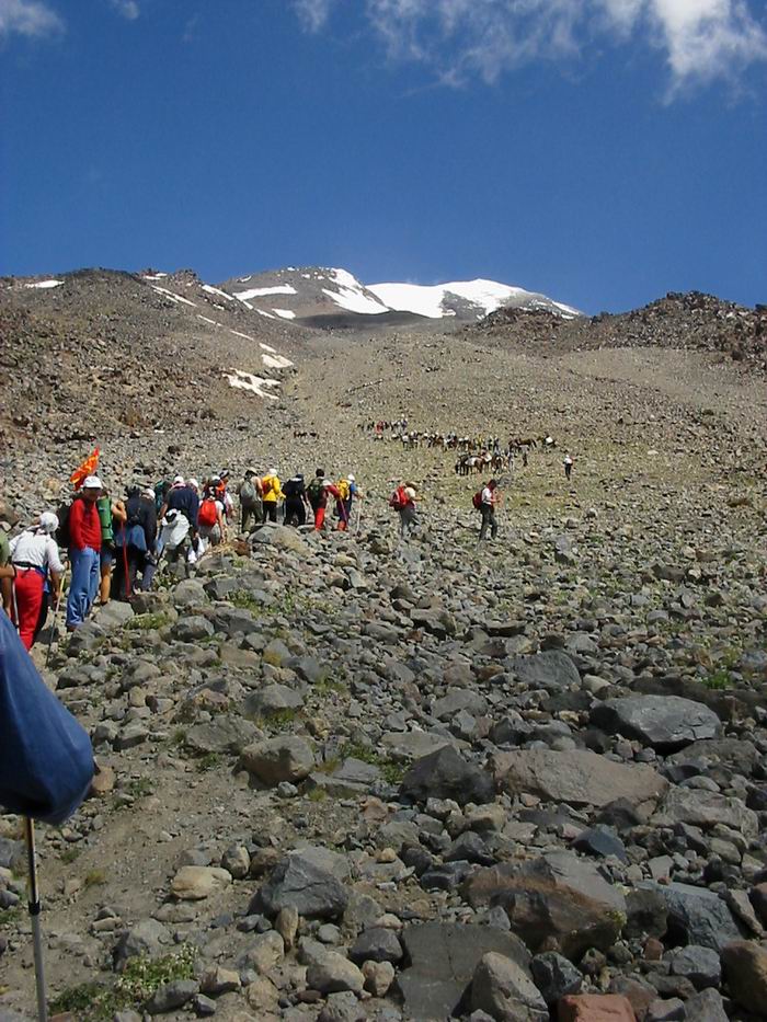
Prof. Frederick Von Parat successfully reached its summit, which Marco Polo said no-one would ever climb, on 9 October 1829. The former president of the Mountaineering Federation, Dr. Bozkurt Ergor on 21 February 1970 made the second ascent. Thousands of visitors came in 1980, and ten years later climbing was banded but this was lifted in 1998 when the Mountaineering Federation gave permission to a group of climbers.
Height: 5165 m.
Location: Eastern Anatolia, near the border with Iran and Georgia, between the Aras and Murat Rivers.
Best Time for Climbing: July to September. Winter climbing is very difficult but extremely rewarding.
Characteristics: Mount Ararat (5165m) is the highest peak in Turkey and Europe. It is a volcanic mountain made up of basalt, which changes to andesite lava around 4000 m. At the summit there is a glacier, and on the eastern slope is the Serdarbulak ridge, with Kucuk (Little) Ararat at 3896m. The height of Mount Ararat, along with its glaciers, geological formations, people, and mountain meadows covered snow has an alluring, almost magical appearance.
Transportation and Accommodations: The Trabzon-Erzurum-Tehran International Highway winds around the foothills of Mt. Ararat and leads to Iran. There are regular air, rail and bus connections between Ankara and Erzurum. Dogubeyazit is the closest city to the mountain, easily accessible from Mt. Ararat and Erzurum. There are a number of restaurants and lodging places in the city and the surrounding area.
Climbing Equipments: Crampons, rope (11mm), an ice pick and safety gear such as an ice-auger and climbing tape.
Summer Ascents: Sleeping bags made for temperatures of -5, -10 ºC, anorak, wind jacket, other camping gear and important supplies.
In order to climb Mount Ararat and/or Little Ararat, permission is required and it is mandatory that climbers begin their journey from the following points.
* Ascents of Mt. Ararat can only be attempted on the portion of the face that is within the district boundaries Dogubeyazit, and must follow the Dogubeyazit - Topcatan village - Eli Ciftligi route.
* Ascents up Little Ararat may only be made along the northwest face. The easiest route in terms of communication and accessibility, and the most commonly followed one, is the southern route.
* Climbers staying at Dogubeyazit can make their final preparations for climbing here and continue by car to the village of Eli. After getting water here, the first campsite, which is at 2800 m, takes 7-8 hours to reach. On the second day, after a 4-6 hour climb, one can expect to reach the next campsite at around 4200 m. It is obligatory for climbers to be equipped with crampons, rope and ice-picks. It takes about 8-10 hours to reach the peak and to return to the first campsite at 2800 m.
ANASAYFA • TURKCE • ENGLISH • ONLINEREZERVASYON • FOTOGALERY • İLETİŞİMFORMU
HOTELORTADOĞU DOĞUBAYAZIT/AĞRI
TURKEY0090-472-3124225